Showing posts with label Billy McVicker. Show all posts

Friday, March 25, 2011

Billyisms

Being friends with someone is one thing. Living with them for a month, is something else. We have now been together for almost a month. We have come to know each other at a very different level - almost all really good.

One of us in particular, is known for his great knowledge, accurate assumptions, and reasonable claims. We know him as Billy. As one of seventeen children he has had no choice but to be infallibly superior.

Here are a few nuggets of his knowledge:

"Chris is short."

"Some birds fly down."

"If it has a front and a back and floats, it's a boat."

"Just hit 'em with a chair!"

"It takes everyone a long time to learn a new game."

"So the shorter you are, the bigger the ape factor."

"When I run, I run for hours." How often do you run? "Never. I ran a lot in P.E."

"I wasn't scared at all, I was like pumped!"

"Chris can't reach it. Basketball it is!"

"What's outside that I can't find on the internet?"

"This is not chicken. There's fur on this. These must be rabbit wings."

"Technically, buffaloes don't have wings."


Maybe you'll be lucky enough someday to hear some of his knowledge first hand... :P

Monday, March 21, 2011

Mdina Archives 3D Cistern Visualization

On Wednesday (3/16/11), we went to Mdina to explore another cistern at The Archives of the Cathedral of Malta. This cistern was especially interesting because of its shape. The cistern consisted of a shaft down the center and two bell-shaped cisterns branching off. The smaller cistern's access point was at about 16 meters underwater down the shaft, while the larger cistern's access point was at about 22 meters down the shaft. Gathering enough sonar data for this cistern was very difficult due to the complexity of two cisterns in one. It was difficult to navigate between cisterns through the shaft while keeping track of the distance moved and the orientation of the ROV. We collected 50 sonar scans in all where 15 of them where side-scans. (The sonar was rotated sideways to collect vertical data of the cisterns).

Over the past few days, Chris and I have been analyzing this data and creating sonar mosaics (the compilation of multiple sonar scans to create a map) in order to create a 3D map of the entire cistern. So far, we have created a 3D map and now I am handing it off to Christina for her to transform it into a pretty 3D visualization. The image below represents a map of the entire cistern, which includes both of the sub-cisterns. (This is before Christina's visualizations). You can see the smaller cistern on the left that branches out from the shaft and the larger cistern is on the right. This map was generated with the sonar data using the sonar mosaics to calculate the ROV position at each of the scans and also SLAM (Simultaneous Localization and Mapping) to help better align the individual scans.

Data Processing!

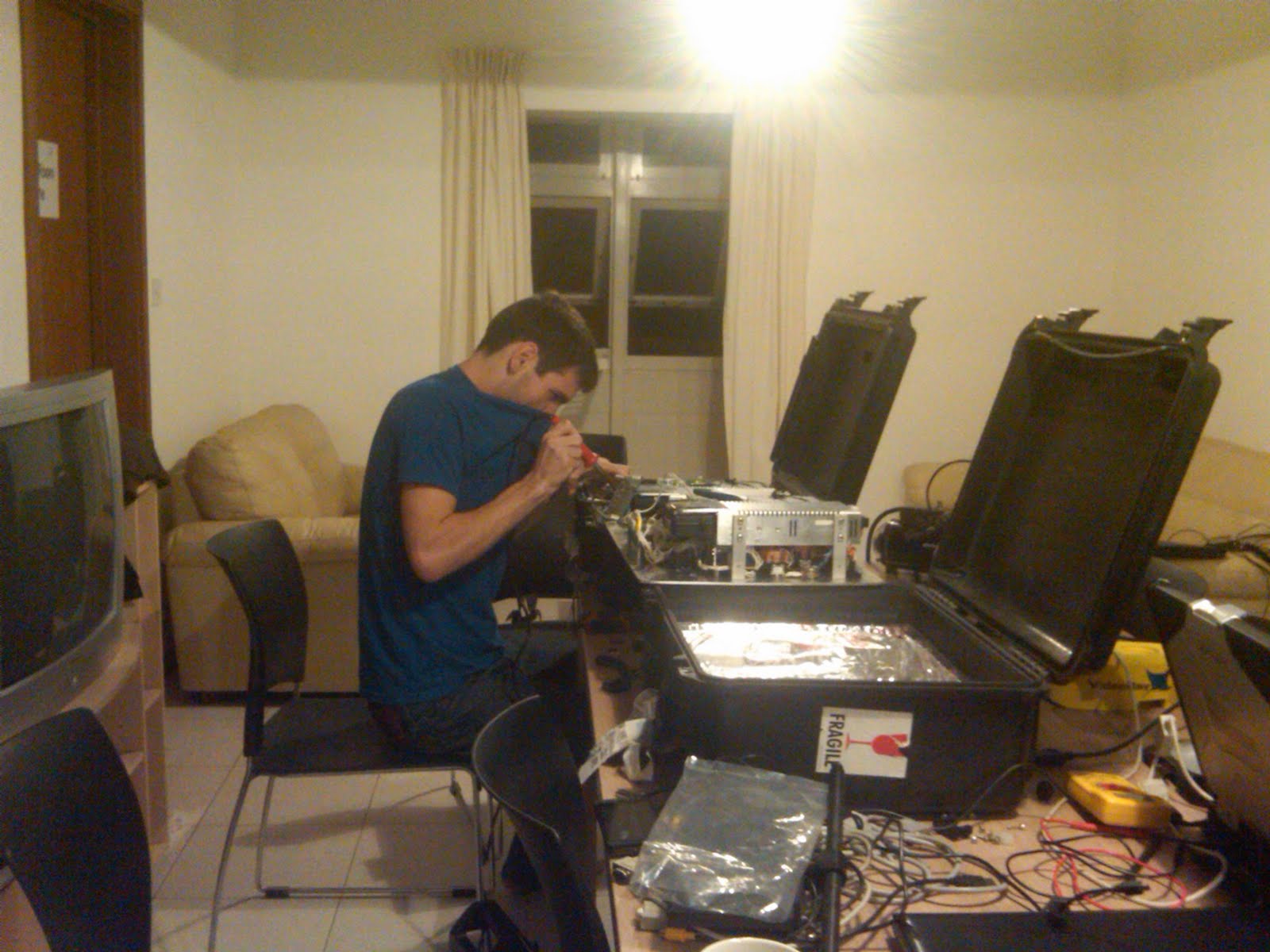
After a few weeks of gathering huge amounts of raw video data it's crunch time! On the left is a computer being used to edit the massive amount of video collected by the ROV into small ~1-4 minute representations of each cistern. Billy, as seen on the right, is creating a 3D map of a cistern with a program he coded almost from scratch.
Some of the challenges I have found with editing the video is a lack of clear video as well as video that shows the ROV moving around the cistern in a fashion that allows anyone to understand where they are in relation to the starting point. Luckily, we have managed to collect so much video that I have been able to splice together many of the video files to create a short and cohesive video for most of the cistern locations we have visited.


Billy and I working side-by-side pushing through all of the collected data


Creating a video of the inside of a cistern by piecing together smaller portions of video taken by the ROV.


Timmy can win a singing contest using sign language.

Friday, March 18, 2011

Inspiring the Next Generation - Teaching Robotics

Part of the ICEX goals this year have been reaching out to elementary school aged children and introducing them to robotics and inspiring them to go into science and technology fields. During the quarter back at Cal Poly, we visited two different 2nd grade classrooms at Pacheco elementary school every Wednesday. We switched off between the classrooms and had hands-on lessons that talked about design, testing and programming. It was very successful. The kids seemed to really enjoy it and retain a lot of what we taught. We even got a book of thank you notes written by all the students afterward – a nice touch.

Originally, that was going to be the extent of our outreach. At the suggestion of Timmy though, we packed a suitcase full of little robots so we could continue the lessons at several Maltese grade schools. We started off with a brief lecture about different types of robots and introduced the robots we brought and the paper disks used to program them.

The disks we used were small circular pieces of paper (that we had to individually cut out beforehand). The robots have two sensors that read the disk as it rotates and determines if the 2 rows of squares are black or white. Depending on the combination of black and white, the robot will go forward, stop, or turn left or right.

We then broke the students into groups of 3-4 and let them each “program” the robot to navigate a simple maze we created on the floor with tape by coloring disks with black pencils and pens. Overall, the students were very excited about it and there were several students who even inquired about where they could get their own robot so they could do more on their own.

It was encouraging to be so enthusiastically received by both the students and faculty of the schools and in addition to being a good educational experience for the students there, it was a great experience for the ICEX team as well to be able to talk with so many students (who represented a variety of ethnic backgrounds).

Wednesday, March 9, 2011

Gozo

In addition to collecting information at various sites throughout Malta, we’ve been able to go to several sites on the smaller island of Gozo. Gozo is only 14km long and 7km wide and has approximately 31,000 residents. It is known as being much more green compared to Malta and the industry is more focused around agriculture. Below is a view over part of the island, as seen from the citadel in Victoria (also called Rabat) which is the capital city of Gozo.

Our sites on Gozo (on Monday) were focused on water galleries (as opposed to cisterns or wells). It was a neat change of pace to see the lay out horizontally instead of relying completely on sonar and video data from the ROV to get an idea of the layout and general structure of the cistern.

We did two sites on Monday. The first one, Ghar Ilma (Water Cave), was at a private residence and was apparently very important in supplying most of the water for the citadel back when residents of Gozo would have to sleep within the protected walls of the citadel (to stay safe from pirate attacks). I was surprised at the extent of this gallery. There were several different passageways and the main one extended for over 900 ft. We collected data for a lot of it, but were unable to map everything due to the limited length of our cable (only 250 ft) and the fact that there was a pile of debris blocking part of the main passageway.

Our second site was another private residence in someone’s garden. We set up in a small grove of tangerine/orange trees and ran the cable down to the water gallery. The depth readings on our control box were still not working properly, but we were able to get good sonar scans for the entire gallery.

After we finished collecting data, we packed up quickly and drove to the ferry in order to catch it on time (so we could meet our driver on the other side at the scheduled time). We got there in time, but almost missed the ferry anyways due to complications getting all of our equipment (a large generator, several large robot boxes, and various other bags and toolboxes) into a luggage container. We did end up making it, enjoyed the beautiful ride back to Malta and concluded another successful day of data collection.

The Cave

Today (Wednesday) we began exploring a cave at St. George's Bay in St. Julian's. It was huge! It is this large, deep pool of water contained completely in this cave. We had a bit of a trek to get to the entrance, and when we got there, we had to walk down a staircase which led to the water. We set up our equipment up near the entrance so we had some light to work in, and Andy and Brig practiced their driving skills for the first time since we've been here in Malta.


Unfortunately, like yesterday, we had a lot of technical problems with the sonar communication (a relatively new problem since Chris showed up...impeccable timing). We ended up deciding to not dedicate too much time initially to troubleshooting the problem, and get on with exploring the cave. We took a lot of video and really just wanted to get a feel for the size and environment of the cave. With 3 days to explore, we wanted the first day to be dedicated to getting a grasp on the cave as a whole.

Around lunchtime, we decided to pull the ROV out, and attempt to do some debugging on the sonar connection. We narrowed the problem down to the actual connection between the ROV and the tether, but were not able to come up with a solution on site.


Deciding to continue with just video, we put the ROV back in the water and I took control of the control box for awhile. My goal was to get as deep into the cave as possible, given the limited amount of cable we had.


After exploring for awhile, I hit a maximum depth of about 35 meters (114 feet!). I went into the cave as far as I could, and when I was pretty sure I had run out of cable, we decided to turn around. Upon trying to surface, I realized that there was a bit of a problem: I had created some significant snags in the tether while driving around. This was probably one of the worst tangles that the ROV had experienced thus far, according Chris, so as one could guess, there was a bit of stress around the cave site. Half of the team was down in the cave, waiting to wrap up the cable as it became untangled, while the other half watched the video feed and attempted to strategize a plan to untangle the ROV. Chris ran back and forth between the computer and the cave to try and quickly solve the problem so we didn't end up becoming completely stuck in this massive cave. It took quite awhile to remedy, but after some careful driving, we were free and to the surface. Getting stuck allowed us to more closely see some of the natural formations of the lower parts of the cave, which were super interesting!


With the significant technical problems of today, we have decided that it would be best to stay home and troubleshoot tomorrow instead of trying to explore the cave with non-functioning equipment. We hope that by Friday, we will be able to have the sonar connected so we can create some maps of the cave (not an easy task), and maybe even connect our second tether so we can explore even deeper!

Saturday, March 5, 2011

Mdina, Round 1

Our site for Wednesday was within the walled city of Mdina (http://en.wikipedia.org/wiki/Mdina). The first cistern was located in a restaurant called Bacchus, which was not open for the day yet.
This caused our time for exploration to be slightly shortened, as we had to be out before they opened. After arriving, during setup and some of the time spent in the cistern, about half of the team was able to wander around the restaurant with the owner getting a bit of a history lesson. There was much history to discuss since the room was built between 1657 and 1660! Since it was before business hours, many people transporting supplies for Bacchus were filtering in and out of the front entrance where we were located. Many stopped momentarily to see what we were doing, and were very interested in our sonar maps of the underside of the restaurant as well as the images we were receiving from the VideoRay.


In an effort to rotate drivers during different sites, Christina watched closely as I drove the VideoRay through this site so she could become familiar with the logging process and hopefully gather useful data. After gathering data for awhile, the ToughBook lost communication with the control box. After a quick bit of unsuccessful troubleshooting, it was about time to leave, so we headed to the next location.

The next spot was The Mdina Experience, right down the street. There was very limited space here, and it was during normal business hours.


There was actually a tour group passing right through our site when we arrived. They watched as we brought in and setup all of our equipment, but weren't interested enough to ask any questions. We switched to the Samsung backup since we thought the problem was with the ToughBook and did not have time to continue troubleshooting it on-site. Slightly different connections had to be made when using the Samsung, since it lacked a serial port, but everything worked out and we got the VideoRay through the small entrance and into the water.

Space was limited, so team members not directly involved couldn't really be present, so exploration presented itself again!

Another restaurant was our final location of the day. The cistern here was located in the basement. We had to walk through the restaurant which caused for some further stares of the other patrons. There was an extremely narrow passageway leading down to the site, and our equipment had to make it carefully down the long staircase. To add a bit to difficulty, the passageway was lined with wine bottles so there was little room for error. Luckily, Tyler and I made it all the way down successfully.

After making it downstairs and setting up, the data collection process began. Christina drove for for the first time on this site, and did an awesome job grabbing sonar scans and video for the cistern we were on top of. This cistern was composed of a large circular room and a narrow hallway that didn't lead to anything. We ended our day here, and loved the view off the balcony behind the restaurant!

Friday, March 4, 2011

Late Night Repairs

When we arrived in Malta on Monday, the LCD in one of the control boxes for the VideoRay was broken. (It was working before we left). Since we have two control boxes, we managed to use the working control box with the VideoRay to continue exploring wells and cisterns. On Wednesday night, it was time to start analyzing the data to verify whether or not it was valid. Only after about 15 minutes, it became apparent through a sanity check that most of the depth measurements were invalid. (The invalid data sets had a depth of -17 meters). After discussing this with Joe and Chris, Joe emailed VideoRay about the problem. They responded within the hour suggesting we disassemble the control box and analyze it for loose connection or faulty components if we were brave enough.

Immediately, I brought out the tools and began tearing it down. During this breakdown process, Joe, Jane, and I began brainstorming about what the problem could possibly be. I decided to start with fixing the LCD screen on the broken control box in order to check if that control box was recording a depth of -17 meters. I began switching out components from the broken control box with the equivalent components in the working control box to consolidate the problem. After ruling out the LCD screen itself and the removable Atmel microcontroller, I melted off the epoxy on the PCB connectors of the LCD control board with a soldering iron and found that switching the LCD control board out with the other control boxes LCD control board solved the problem. When switching these boards, both of the control boxes began to function properly (as far as the LCD screen goes). After discussing this with Joe and Jane, we concluded that the problem must have been from the epoxied connectors since the both of the LCD screens worked after switching them out.


It was about 5am, Malta time, when we reassembled the boxes and calibrated the compasses for the next day. We then logged data using both of the control boxes separately with the VideoRay out of water and found that the depth reading was about 1 meter. We decided this value was better than -17 meters and we only needed to calibrate the depth sensor, which could be done in the morning. This was about the time we called it a night.

Tuesday, March 1, 2011

A Troublesome Start

Unfortunately, our first technical blog will start a bit dreary. After the hustle and bustle of our many flights, and the changing of connections with our luggage, damage was done to the ROV’s stand. The picture shown below illustrates the complete fracture of the stand in two areas, leaving the stand unstable and hardly strong enough to hold its own weight on dry land. Our second technical problem of the day was also a result of the long journey and the solution to this problem is yet to be solved. One of the control boxes for the ROV no longer shows a display reading any of the crucial coordinates such as compass direction, depth and time. Although these technical problems are certainly not a great way to start our research in Malta, we still maintained high spirits and worked to solve these problems before days end.

Before we could fix these issues we needed to calibrate the depth sensor on the ROV with an air gun to 50 psi. The ROV uses a pressure reading to determine an accurate depth measurement shown in the control box. The problem was we did not have an air gun but luckily Timmy’s close friend Erin was here to help. Erin was kind enough to pick up Joseph and I, along with the ROV, took us to his boat on a small island called Manoel to calibrate the depth sensor. The first obstacle came in the form of a 3 foot gap between the landing and the 1 ft wide ramp leading to the boat with the equipment needed to calibrate the ROV. What would normally be a simple stretch or a light jump became very difficult with a large 45 lb. box holding the cables to the ROV. I almost attempted the jump but realized that would not end well and convinced Erin to dangerously lean over the ramp and grab the box from me. With the first hurdle out of the way we proceeded to calibrate the depth sensor with an air compressor he had on board the boat. Erin did not have the proper fighting to pressurize the small hole in the ROV to 50 psi but with a little ingenuity and some quick thinking by Erin we were able to cut the air hose and create a seal around the pressure sensor. After a few failed attempts at calibrating the pressure sensor, Joe and I timed the air gun to get the pressure coming from the gun to be 50 psi right when Joe pressed the calibrate button, ensuring an accurate calibration. Our test with Erin’s underwater sonar matched the readings we were seeing on the control box ensuring our make-shift calibration was successful. After all the troubles of getting the correct pressure dialed-in, the depth calibration was finally correct but there was still the ROV stand and the control box to fix.

Although our ROV stand was broken, our backup (nonfunctional) ROV became very useful for spare parts and the stability was renewed again when we switched the two stands. We were unable to fix the control box for the time being but we believe it may just be a loose connection and we will investigate this problem as soon as we are able to.


Picture: The ROV's fractured stand (some of us may refer to them as the "legs" of the robot)

Monday, February 28, 2011

The Adventures in Malta Begin

So the day we have all been looking forward to finally came. We arrived at the San Luis Obispo, CA airport around 4:30am PST Saturday morning. Our plane left around 6am and flew to San Francisco, CA. Next, we flew to Chicago and then immediately hopped on a plane to Frankfurt, Germany. The flight to Frankfurt was the longest, which lasted 8hrs and 10min. I found this flight to be very culturally diverse due to the Frankfurt airport being a connecting spot for many other international flights. Specifically, I found it interesting how all the announcements were proclaimed first in German and then in English. (German because the airline was Lufthansa, which is a German airline). We had about an 1hr 30min layover in Frankfurt, which was spent wandering in the terminal trying to find our gate for the last flight and then eating breakfast. The last flight from Germany to Malta lasted about 2hrs and 30min. When flying in, we first saw the island of Gozo. This island is located north west of Malta and is much smaller. Finally, when Malta was in sight, it was interesting to see how large the island actually is. I always imagined Malta as a small island with not as much open-space, but found myself shocked when I saw much open-space and multiple distinguishing cities on the island. Once we landed, we gathered up all our luggage and located our driver.

Driving from the airport to the apartments was a great cultural experience in that most of us expressed spurts of shock/fear due to driving on the left side of the road. It became a quick realization that Malta's roads are very narrow and dangerous. Most of the cars are extremely small, which is necessary in order to fit down most of the roads in the city. Once we got to the apartments, the manager of the apartments assigned us our rooms, gave us our keys, and then informed us about stores and the cities nearby. We are staying at the am Learning Studio where many travellers come to Malta to learn English. We have two apartments where each one has three bedrooms and two bathrooms along with a kitchen and living room.

After we settled in, Andy, Jeff, Brig, and I headed to the hardware store to pick up an extension cord and also power converters from 220V EU style to 110V American style. This was a great time to see the architecture of Malta and learn the streets we will explore in the next month. In the meantime, Joe and Tyler went with Timmy to calibrate the robot's depth sensor, and Jane, Christina, and Jennifer went shopping for food and some necessities. This all led to resting and dinner. We're all pretty tired and heading to bed to catch up on all the lost sleep due to the time change and travelling.

For pictures refer to the previous post by Brig.

Thursday, February 17, 2011

Research Project Discussion at Backstage - 2/15/11

So I got one picture...

Hopefully it's an okay summary of our meeting with Timmy Gambin and the awesome insights he was able to give into our individual research projects and also just some useful general knowledge about Malta.

Can't wait to talk with him more!

Wednesday, February 9, 2011

Archeological Knowledge of Cisterns and Water Management in Malta

Abstract
Water is a vital resource for life to survive in all environments. The Maltese have been struggling with the lack of water as far back as 3000 BC. My research analyzes how the Island of Malta has handled the water crisis throughout many centuries and continues to handle it today. Through analysis of research in books by Garry Hogg, Quentin Hughes, and a few others, I have found that Malta designed its water management system around the uses of cisterns throughout local communities and large temples. These cisterns primarily were designed as water tanks to become the primary source of fresh water during the dry summer months and were replenished with fresh water during the rainy season. Malta’s terrain is very rocky and largely composed of limestone. This prevents the absorption of rainfall leading to the majority of this water escaping as run-off to the Mediterranean Sea. With the construction of the Wignacourt Aqueduct during the 16th century which transported fresh water from Mdina to Valleta, the new capital city of Malta, water resources became more accessible allowing for agriculture to advance beyond what it was previously capable of. The cisterns were used for many centuries as the main source of storage of fresh water. Even today, thousand year old cisterns are still used for irrigation and plumbing (usually not drinking due to bacteria). As technology advanced in the 19th century, the Maltese now use desalination methods to support the countries need for fresh water. Desalination methods account for about 50% of the fresh water in Malta. This project dives deeper into the analysis of how the water crisis in Malta has impact the culture and the development of water storage methods from 3000 BC till now.
Locations of Site Visitors