Sunday, March 13, 2011

Valletta - A Cultural Experience

As part of Jane’s last day in Malta, we spent the morning exploring St. John’s Co-cathedral in Valletta and briefly around the city. St. John’s Co-cathedral is dedicated to St. John the Baptist and was originally commissioned in 1572. It has gone through a number of redecorations and restorations (particularly after bombing attacks in WWII) but there is certainly a lot of history to soak up among the highly ornate walls.


As part of the admission, we were given audio guides that explained a lot of the history and significance of different parts of the church, which definitely helped in appreciating the smaller details. There was also a museum part with old church robes, choir books, tapestries and several famous paintings, including 'Salome with the Head of John the Baptist' by Caravaggio. I found it particularly interesting to see the old choir books with a very different method of depicting the musical notes and rhythms than I am used to seeing. Unfortunately, no pictures were allowed in that area though. Below is a view of the highly decorated front of the church.


Afterward, we took some time to wander around Valletta briefly. It's a very interesting city and I love the look of all the narrow streets and old buildings.


Another view of Valletta below. The gates open up to the harbor and a spectacular view across the water.


As we were leaving the city to catch a bus to our next destination, we found the entrance somewhat blocked by a group demonstrating for peace in Libya. It was a fairly small group and their demonstrations were not wild or dangerous, but there were Maltese police there just in case to watch over the event. It was interesting to witness a current event play out firsthand as opposed to just reading it all in the news. A link to an article about it: http://www.timesofmalta.com/articles/view/20110224/local/anti-gaddafi-demonstration-set-for-saturday-in-valletta

Friday, March 11, 2011

The Cave of Wonders

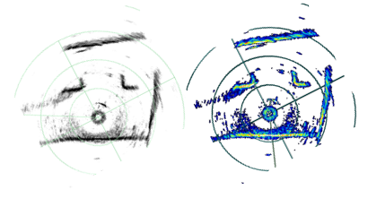
You will wish you were here! Day two of the cave had a few exciting discoveries... as well as a couple of newly created set-backs. Because our sonar was out of commission the first visit, we spent all of Thursday repairing and splicing the tether that caused the problem. Today, we finally had a chance to map the cave and the wonders contained within its depths.


The newly repaired tether worked like a charm as we mapped the surface of the first pool in the cave. We also mapped varying depths at multiple locations in the cave that we hope to "paste" together. This will hopefully be enough data to completely represent the water within the pool in the cave. In addition to horizontal scans with the sonar, we ran a couple of lengths in the pool with the sonar strapped vertically to the ROV. This will provide us with two sets of dimensions to log the depth of the pool. We used this method primarily to make up for our faulty depth sensor in the ROV's control box.


After mapping the pool, I drove the ROV around to get some close up video of the sides and bottom of the pool. I found a lot of interesting things... a couple of tires and oil bins, plenty of rubble, bottles, and occasional sections of wood. One particular piece of wood had a community of water creatures... either miniature crawdads or a type of shrimp. It was pretty cool!


Unfortunately, our repaired cable suddenly failed and we lost driving ability for the robot. We switched to our other tether, but that one didn't connect sonar, so we only did visualizations from then on.

All in all, the cave was very exciting. I only wish I had my scuba gear to dive down in it!

(More?) Hardware Repair

So we decided to stay home on Thursday (March 10th) after running into some hardware troubles on Wednesday and ended up getting a lot of troubleshooting done. Our major goals for the day were making the partial ROV water-proof so that we could check its depth sensor in our makeshift pool (a large trashcan), checking the depth sensor of the full ROV, and doing some work on one of our tethers so that we could get full communication with the ROV (one of the problems we experienced Wednesday).

Tyler and I worked with the ROV and Brig and Jeff took on the tether job. We hoped to meet up later in the day to connect the 2 hopefully-fixed pieces of hardware. Tyler and I put the trashcan into the shower and filled it up with water.

We waterproofed the partial ROV and put it in the water for the first time since we've been here in Malta (we had been primarily using it for parts). We used both ROVs and both of our control boxes to test the depth sensors. We received inconsistent readings of depth on the control boxes, and could not communicate with the sonar unit at all. After some testing, we took a break and got some McDonald's coffee down the road. We were even graced by Timmy's presence midway through our day.

Jeff came down and finished up splicing the new piece of the tether together so that we could combine our jobs from the day.

The fixed tether solved the sonar communication problem completely! We now knew that the problem was in the other tether (the one not spliced) so we could now actually get sonar data from the cave! We also tested both cables connected in tandem so that we might be able to get some extra length in the huge cave. The cables connected and were able to control the ROV, but we still did not have sonar communication, which again assured us that the error was within the tether.

The final step was to waterproof the new connection. This required wrapping each connection in electrical tape to prevent shorts, sealing all the connections with epoxy, heat shrinking the epoxy, covering this in a sturdy hose-like wrap, and finally epoxying the ends of the cover.


By the end of the day, the ROVs were back together and waterproofed, and the tether could now communicate with the sonar. Although we lost a day at the cave, we were able to successfully remedy some major problems, and the entire team felt like it was a good choice.

Wednesday, March 9, 2011

Gozo

In addition to collecting information at various sites throughout Malta, we’ve been able to go to several sites on the smaller island of Gozo. Gozo is only 14km long and 7km wide and has approximately 31,000 residents. It is known as being much more green compared to Malta and the industry is more focused around agriculture. Below is a view over part of the island, as seen from the citadel in Victoria (also called Rabat) which is the capital city of Gozo.

Our sites on Gozo (on Monday) were focused on water galleries (as opposed to cisterns or wells). It was a neat change of pace to see the lay out horizontally instead of relying completely on sonar and video data from the ROV to get an idea of the layout and general structure of the cistern.

We did two sites on Monday. The first one, Ghar Ilma (Water Cave), was at a private residence and was apparently very important in supplying most of the water for the citadel back when residents of Gozo would have to sleep within the protected walls of the citadel (to stay safe from pirate attacks). I was surprised at the extent of this gallery. There were several different passageways and the main one extended for over 900 ft. We collected data for a lot of it, but were unable to map everything due to the limited length of our cable (only 250 ft) and the fact that there was a pile of debris blocking part of the main passageway.

Our second site was another private residence in someone’s garden. We set up in a small grove of tangerine/orange trees and ran the cable down to the water gallery. The depth readings on our control box were still not working properly, but we were able to get good sonar scans for the entire gallery.

After we finished collecting data, we packed up quickly and drove to the ferry in order to catch it on time (so we could meet our driver on the other side at the scheduled time). We got there in time, but almost missed the ferry anyways due to complications getting all of our equipment (a large generator, several large robot boxes, and various other bags and toolboxes) into a luggage container. We did end up making it, enjoyed the beautiful ride back to Malta and concluded another successful day of data collection.

Projective Texturing of Cisterns


For the final presentation of the cistern exploration project, all of the video and images will be mapped to the geometry generated from the sonar data. The screenshot below is a mock world generated to serve as example data extracted from sonar. Using mathematical calculations, the images are loaded into a program and projected onto the geometry (just like you would think a projector to work) to make the world look more realistic and similar to what it actually looked like from the perspective of the robot. There is currently only one projection of one image taken of a cistern a couple of years ago.


At this point, there is certainly more work to be done to merge our actual data and images together. The previous plan was to automate the video frame extraction with the location and orientation of the robot and project it. After completing many projects, we realized that it would be near impossible to complete this automatically and accurately.

Currently, my plan is to (once the geometry is loaded into the program) load images that correspond to the cistern and scan through them until one matches the current orientation within the world. At this point, the image projection will be saved, and a new image can be loaded to project and save to overlay or stitch with previous projections. This method will be an easy way to accurately bring multiple images together and place them in the right place in the geometry to make the world realistic.

The Art of Sonar Mosaics

Hand-Mapping a cistern using sonar scans can be quite a tedious but rewarding task. After the many hours spent in the field collecting data there is still the sometimes overwhelming task of analyzing 10's of sonar scans for each cistern. To make this job a bit easier, I like to think of each sonar scan as a piece of a puzzle. At first, I am given a number of pieces in the form of sonar scan data for each cistern and it is my job to put them together. Each scan gives a limited visibility of the cistern but with all of the pieces properly placed, a relatively accurate 2D representation of the cistern can be achieved.

Here is a general overview of one of the map-making processes:

First, I open one of the sonar scans and take a screen shot of the entire scan.
A black and white representation of the scan is used to clearly indicate what is a wall, shown in black, and what is water/data that cannot be collected, shown in white.


Next, I crop the screen shot to only show the sonar data and alter the transparency to allow multiple sonar scans to overlap. For this example I have changed the color of the walls to blue to show where this particular scan overlaps in the final map. The image is then rotated to best-fit the current map.

Finally, each useful piece of sonar data is pieced together to form a sonar mosaic of the cistern. This particular mosaic is one of the more recent cisterns we visited in the Wignacourt Museum.


Timmy wins every game of Connect Four in 3 moves.

Exploring the Catacombs

On Friday (March 4, 2011), we visited the Wignacourt Museum in Rabat, Malta (just outside of Mdina) to explore two cisterns with our robot. This museum is known for the location of St. Paul's Grotto (a small cave), which is believed to be the place of St. Paul's imprisonment on the island of Malta. This site is also known for its catacombs, which accommodated over 1,000 corpses. During World War II, these catacombs were then used for bomb shelters for British soldiers. Between exploring the cisterns with the robot, we were able to explore these catacombs.


The cisterns that were explored at this site were at most 2 meters deep. One of the cisterns was estimated to be circular with a 2 meter diameter and also a 3 meter tunnel.


The other cistern was square with dimensions estimated to be 7 meters by 4 meters. This cistern contained two pillars with a 1 meter deep reservoir about 1 meter by 1.3 meters. We did find some garbage in this cistern and actually got the vertical propeller caught in fishing wire. Other than that, we were able to successfully collect enough static sonar scans to cover all the area of the cistern. This site was very successful and the on-site priest, Father John, was very accommodating.

The Cave

Today (Wednesday) we began exploring a cave at St. George's Bay in St. Julian's. It was huge! It is this large, deep pool of water contained completely in this cave. We had a bit of a trek to get to the entrance, and when we got there, we had to walk down a staircase which led to the water. We set up our equipment up near the entrance so we had some light to work in, and Andy and Brig practiced their driving skills for the first time since we've been here in Malta.


Unfortunately, like yesterday, we had a lot of technical problems with the sonar communication (a relatively new problem since Chris showed up...impeccable timing). We ended up deciding to not dedicate too much time initially to troubleshooting the problem, and get on with exploring the cave. We took a lot of video and really just wanted to get a feel for the size and environment of the cave. With 3 days to explore, we wanted the first day to be dedicated to getting a grasp on the cave as a whole.

Around lunchtime, we decided to pull the ROV out, and attempt to do some debugging on the sonar connection. We narrowed the problem down to the actual connection between the ROV and the tether, but were not able to come up with a solution on site.


Deciding to continue with just video, we put the ROV back in the water and I took control of the control box for awhile. My goal was to get as deep into the cave as possible, given the limited amount of cable we had.


After exploring for awhile, I hit a maximum depth of about 35 meters (114 feet!). I went into the cave as far as I could, and when I was pretty sure I had run out of cable, we decided to turn around. Upon trying to surface, I realized that there was a bit of a problem: I had created some significant snags in the tether while driving around. This was probably one of the worst tangles that the ROV had experienced thus far, according Chris, so as one could guess, there was a bit of stress around the cave site. Half of the team was down in the cave, waiting to wrap up the cable as it became untangled, while the other half watched the video feed and attempted to strategize a plan to untangle the ROV. Chris ran back and forth between the computer and the cave to try and quickly solve the problem so we didn't end up becoming completely stuck in this massive cave. It took quite awhile to remedy, but after some careful driving, we were free and to the surface. Getting stuck allowed us to more closely see some of the natural formations of the lower parts of the cave, which were super interesting!


With the significant technical problems of today, we have decided that it would be best to stay home and troubleshoot tomorrow instead of trying to explore the cave with non-functioning equipment. We hope that by Friday, we will be able to have the sonar connected so we can create some maps of the cave (not an easy task), and maybe even connect our second tether so we can explore even deeper!

Good day!

After a long and hard battle with camera controls in the visualization of our 3D map of Malta, I have finally got them working. My version of Malta is still looking a little orange, but at least I can see how orange it is from all angles.

On another high note, we had the unique privilege of exploring a cave near St. George's bay. This is the one site I was looking forward to the most prior to the trip. I actually had a great conversation about this with a girl on the plane to San Francisco (and in the off-chance that you're actually reading this, Katie, I'd like to get in touch :).

The cave definitely did not disappoint. As we descended into it I was hit both by surprising warmth and overwhelming darkness. My small flashlight did little to illuminate our way and we almost ended up walking straight into the crystalline water because of how hard it was to tell where the dry ground ended. Once we got the ROV in the water and turned on we got a beautiful view of the rocky underwater. There were a lot of technical issues so data collection was at a minimum, but the trip was well worth it and I can't wait to go back on Friday.

Tuesday, March 8, 2011

The Legend of the Pygmy Hippo

A long, long time ago time ago a magnificent species walked the earth. It was found only on a small island in the Mediterranean, the island of Malta. Long separated from its mainland parents these animals evolved having a unique trait, they were 1/3 the size of their parents. These were in fact, pygmy hippos. Known as Hippopotamus melitensis, they stood only 80 cm high. Plagued by the incidence of insular dwarfism, evolution of a smaller species due to land restriction, their isolation has made them unique. Having first arrived on the land we now Malta by crossing the land bridge during the ice age, they became isolated once this disappeared. These hippos existed during the Pleistocene (2,588,000 to 12,000 years BC), long before the building of the oldest stone structure in the world, the Ggantija Temples, found on the island of Gozo.

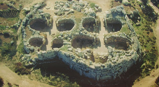
We were privileged enough to explore these temples on Tues, March 8th. The temples themselves had something in common with the hippos - they were much smaller in person than they appeared in pictures. Constructed to represent the earth mother, the two temples consist of multiple round open rooms. The pictures of these temples show these multiple circular rooms for worship - an intriguing pattern when viewed from above. This construction is an incredible feat as some of the larger stones weigh many tons, and were assembled to their present position through human strength and early innovation.


I was most impressed with how well these structures have held up considering they were built 5,800 years ago. Despite the wearing of the stone, and age the of evidence (and removal to museum sites), the unique features were still visible even to my untrained eyes. I could see how the location was a place of peace, offering a beautiful view overlooking the island, tall green grass all around, and an amazingly beautiful structure to offer up worship. I would have loved to find a small area of the temple to curl up and read a good book, enjoying the clean air and sunshine.


It is unfortunate that the people who built the Ggantija Temples did not have a chance to interact with the pygmy hippos as they became extinct long before evidence of any human life on Malta. However, these magnificently small animals were companioned on the island by another small creature - the pygmy elephant, Elephas falconeri, whose story is similar to that of the hippo, and stood only 90 cm high.


We were first told about these unique creatures during Timmy's visit to San Luis Obispo, CA. He warned us, "Watch out! You might see them roaming the land." Little did I know, it is only Timmy who has the power to awaken the ancient species. As I began to visualize these two species, a vision of epic hippo and elephant battles danced in my head. Now, I'm not going to lie - even though I knew it was never possible - I had high hopes for seeing these elephants and hippos roaming through the streets of Valletta, or tromping through the countryside. And to my disappointment - I have yet to see any hippos or elephants.

Locations of Site Visitors