Showing posts with label Sonar. Show all posts

Monday, March 21, 2011

Data Processing!

After a few weeks of gathering huge amounts of raw video data it's crunch time! On the left is a computer being used to edit the massive amount of video collected by the ROV into small ~1-4 minute representations of each cistern. Billy, as seen on the right, is creating a 3D map of a cistern with a program he coded almost from scratch.
Some of the challenges I have found with editing the video is a lack of clear video as well as video that shows the ROV moving around the cistern in a fashion that allows anyone to understand where they are in relation to the starting point. Luckily, we have managed to collect so much video that I have been able to splice together many of the video files to create a short and cohesive video for most of the cistern locations we have visited.


Billy and I working side-by-side pushing through all of the collected data


Creating a video of the inside of a cistern by piecing together smaller portions of video taken by the ROV.


Timmy can win a singing contest using sign language.

Friday, March 11, 2011

The Cave of Wonders

You will wish you were here! Day two of the cave had a few exciting discoveries... as well as a couple of newly created set-backs. Because our sonar was out of commission the first visit, we spent all of Thursday repairing and splicing the tether that caused the problem. Today, we finally had a chance to map the cave and the wonders contained within its depths.


The newly repaired tether worked like a charm as we mapped the surface of the first pool in the cave. We also mapped varying depths at multiple locations in the cave that we hope to "paste" together. This will hopefully be enough data to completely represent the water within the pool in the cave. In addition to horizontal scans with the sonar, we ran a couple of lengths in the pool with the sonar strapped vertically to the ROV. This will provide us with two sets of dimensions to log the depth of the pool. We used this method primarily to make up for our faulty depth sensor in the ROV's control box.


After mapping the pool, I drove the ROV around to get some close up video of the sides and bottom of the pool. I found a lot of interesting things... a couple of tires and oil bins, plenty of rubble, bottles, and occasional sections of wood. One particular piece of wood had a community of water creatures... either miniature crawdads or a type of shrimp. It was pretty cool!


Unfortunately, our repaired cable suddenly failed and we lost driving ability for the robot. We switched to our other tether, but that one didn't connect sonar, so we only did visualizations from then on.

All in all, the cave was very exciting. I only wish I had my scuba gear to dive down in it!

Wednesday, March 9, 2011

The Art of Sonar Mosaics

Hand-Mapping a cistern using sonar scans can be quite a tedious but rewarding task. After the many hours spent in the field collecting data there is still the sometimes overwhelming task of analyzing 10's of sonar scans for each cistern. To make this job a bit easier, I like to think of each sonar scan as a piece of a puzzle. At first, I am given a number of pieces in the form of sonar scan data for each cistern and it is my job to put them together. Each scan gives a limited visibility of the cistern but with all of the pieces properly placed, a relatively accurate 2D representation of the cistern can be achieved.

Here is a general overview of one of the map-making processes:

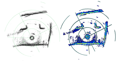
First, I open one of the sonar scans and take a screen shot of the entire scan.
A black and white representation of the scan is used to clearly indicate what is a wall, shown in black, and what is water/data that cannot be collected, shown in white.


Next, I crop the screen shot to only show the sonar data and alter the transparency to allow multiple sonar scans to overlap. For this example I have changed the color of the walls to blue to show where this particular scan overlaps in the final map. The image is then rotated to best-fit the current map.

Finally, each useful piece of sonar data is pieced together to form a sonar mosaic of the cistern. This particular mosaic is one of the more recent cisterns we visited in the Wignacourt Museum.


Timmy wins every game of Connect Four in 3 moves.
Locations of Site Visitors